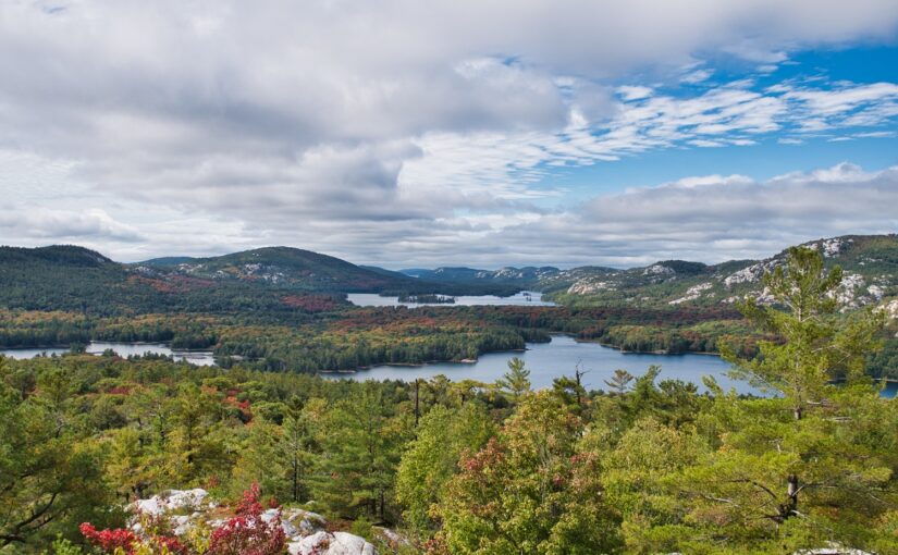
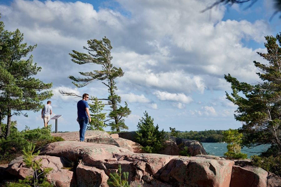
You’ve seen the Instagram snaps and magazine covers. You dream of the view from white quartzite mountain ridges, of gazing across the landscape that inspired the Group of Seven.
Pump the brakes a moment, though. Did you see that word “mountain”?
It’s not a metaphor.
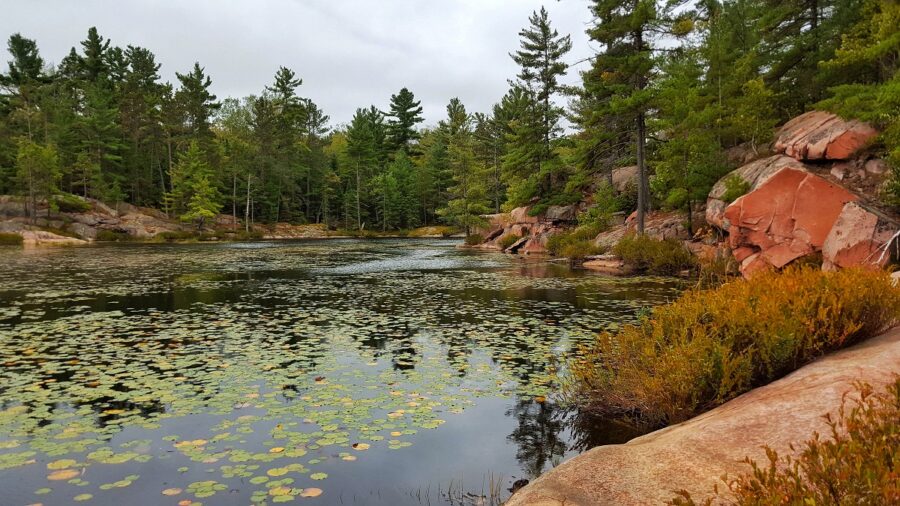
The Crack is an extremely challenging hike in the LaCloche Mountain range at Killarney, a wilderness class park.
Proper preparation is paramount to getting up and down safely. Otherwise, hikers face a very real danger of getting lost, dehydrated, and/or seriously injured.
If you’re planning to hike The Crack, please fully review this post as part of your planning process for hiking this iconic trail:
- Is this something I can do if I’m not an experienced hiker?
- I hike regularly — is there anything particular I should know?
- How long will the hike take me?
- How difficult is the trail / what will the terrain be like?
- Is the trail well-signed / is there a map?
- Can I bring my kids?
- Can I bring my dog?
- What should I wear / pack?
- What should I NOT pack?
- How much does it cost to visit Killarney for a day hike?
- Where do I park?
- What should I do if the parking lot’s full?
- Does the park have other hiking trails?
- Can I make a campfire along the way or at the top?
- Can I camp on top of The Crack?
- Should I turn back if it rains?
- Should I be worried about bears?
- What should I do if I get lost or hurt?
- Can I hike the trail in the winter?
- What can I do to protect the trail?
1. Is this something I can do if I’m not an experienced hiker?
If you’re not an experienced hiker, please consider carefully before tackling this trail. If you’re used to:
- pavement, flat terrain, or level trails
- medium inclines or gradual hills
- shorter (1-2 hour) hikes
- long walks (3-4 hours) on pavement or boardwalks
…The Crack will be a major challenge. We’ll say it again: you’re climbing up a mountain in a wilderness park.

While you can conquer the Crack as a less-experienced hiker, if you fail to prepare, it may be that this trail conquers you instead.
And on difficult trails like this, that represents a very real safety risk.
If you’re not experienced in rugged trails, please review this entire blog post before making your decision. Evaluate your skills, health, and limits fairly.
Remember: there’s nothing wrong with starting with a less challenging trail.
2. I hike regularly and on challenging trails — is there anything particular I should know?
Please take this to heart: The Crack is a difficult trail, even for experienced hikers.
Underestimate it at your peril.
Given its rugged terrain, long distance, and steep incline, this is Killarney’s toughest trail, and one of the most challenging hikes in the province.
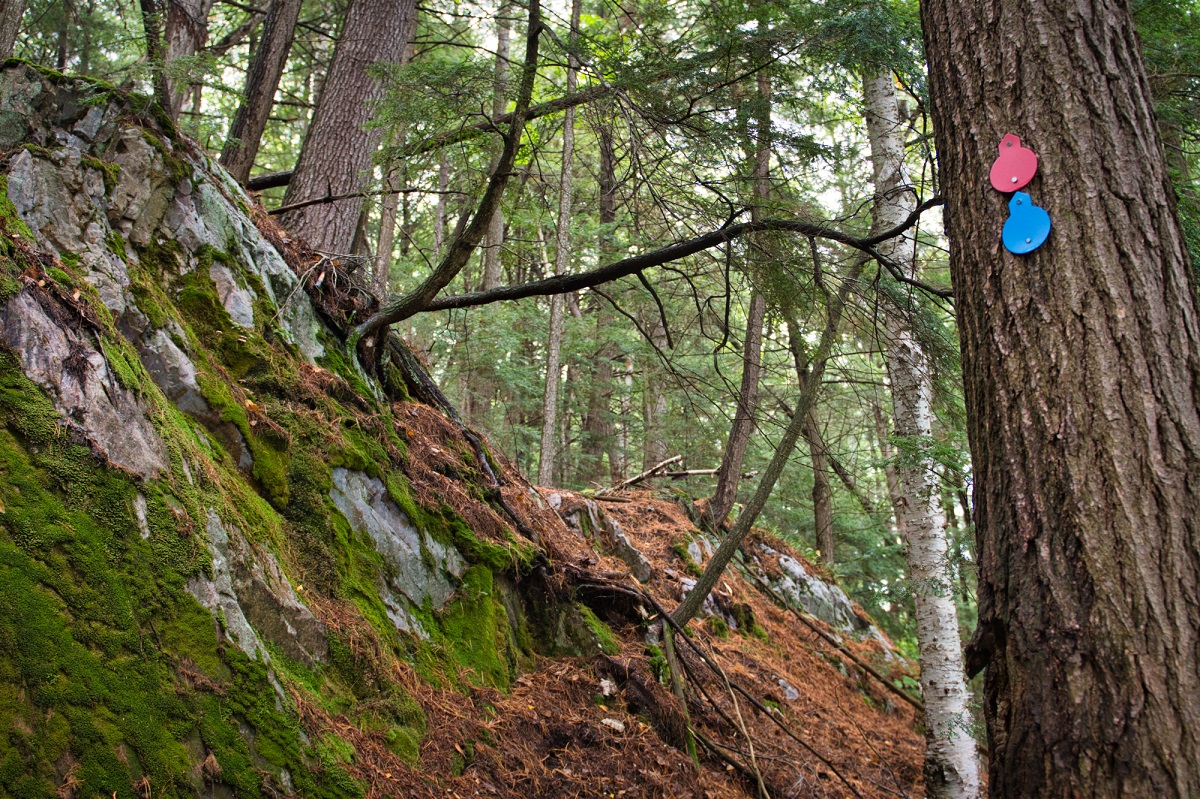
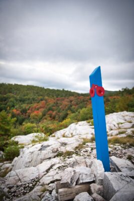
One important thing to keep in mind: The Crack (red markers) is a linear trail, rather than a loop, however it is also part of an 80 km backcountry trail (blue markers).
Once you reach the top, it is critical to follow the red markers back the way you came. If you start seeing only blue markers, you’ve gone the wrong way.
Please use your experience to prepare responsibly, and review the rest of this post for trail-specific recommendations.
3. How long will the hike take me?
The important question here: “When does it get dark?” This is a tough trail in broad daylight; it’s downright treacherous in the dark.
Please plan to be back at the trailhead at least a full hour before dark. During summer months, we don’t recommend starting this trail later than 5:00 pm.
In the fall, when the sun sets earlier, you’ll need to start considerably earlier than 5:00 pm to avoid scrambling down rocks in the dark.
Typically, this trail will take four hours for experienced hikers, return trip.
If you’re less experienced, give yourself a full extra hour.
Whatever your experience level, don’t forget to factor in photo and picnic time. The views at the top are breathtaking, and it can be easy to lose track of time.
4. How difficult is the trail / what will the terrain be like?
This is Killarney’s most difficult trail, and it’s one of the most challenging hikes in the province.
Don’t be fooled by its leisurely start. The gentle slope and mixed forest quickly give way to rocky scrambles and steep inclines.
Be prepared for:
- sharp rocks that get very slippery when wet
- large and small cobble
- crumbly, erosion-prone soil
- exposed roots and other tripping/slipping hazards
- large boulders
This is a trail that often takes all four limbs in its many scrambles. You’ll need good balance. Despite being extremely steep, going up is actually easier than coming back down in many places.
5. Is the trail well-signed / is there a map?
Yes. Be sure to stop in at the George Lake permit office to pick up a map before starting your hike.
(Yes, a physical map is a must. Phones are a great back-up, but they can be dropped, lose signal, become drained…)
The Crack is marked with red signs. In wooded areas, look for red markers on trees. In open rock areas, look for red posts.
If you see only blue signs (no red), turn around — you’ve gone the wrong way and are heading out onto the LaCloche Silhouette Trail (which is 80 km long!).
6. Can I bring my kids?
Yes, but please consider their ability carefully.
This trail is too challenging for children under seven. Strollers and wagons cannot be used on this trail.
When considering this hike for older children, please factor in their experience and activity level. If your child isn’t used to longer hikes or excursions, this isn’t a good introductory hike — consider starting with another trail in the park.

Remember that this trail includes rocky scrambles, slippery cobbles, and steep climbs. In many places, you’ll need all four limbs yourself — you’ll want to be confident your child can complete the trail with only minimal adult support.
Be sure to bring enough water for each child (for instance, if you’re hiking with two children, you should be packing at least 6 L of water), and that they have appropriate footwear.
7. Can I bring my dog?
Dogs are permitted, however — again — please consider the safety and enjoyment of both you and your pup. This is not a trail that is well-suited to four-legged companions.
Dogs must remain on-leash at all times. A leash and an excited dog are rarely a recipe for safety on a tough trail, especially when navigating rocky scrambles. You will often need both hands just to complete the climb.
Likewise, The Crack is not suitable or safe for many dogs. In particular, small dogs and older dogs will struggle to navigate the rugged terrain, and should not attempt this hike.
If you do decide to bring your dog, please follow all pet rules, particularly keeping them on a leash no longer than 2 m. An unleashed dog running ahead on the trail might provoke a bear and lead it back to you.
You’ll also need to carry enough water to keep your dog hydrated too.
8. What should I wear / pack?
The number one item to pack on this hike? Water.
Please ensure every member of your group has — at minimum — 2 L of water.
Next, consider your footwear. On this rough and rocky trail, you’ll want a hiking shoe or boot with an aggressive tread, ideally with a high ankle cut for stability. Running shoes don’t have the same grip. Be sure to break your footwear in before you tackle this hike.
Do not attempt this hike in sandals, Crocs, rubber boots, or flipflops.
Bring what you need to keep from getting lost:
- map of trail (pick up a paper copy from the George Lake permit office)
- compass and/or GPS device
Please be sure to have a phone and/or satellite phone for use in an emergency.
You may also want:
- snacks to keep your energy up
- first aid kit
- hat / sunscreen
- weather-appropriate clothing, including layers
Be careful to keep your pack manageable; you’re going to be carrying it up a mountain for the next four to five hours!
9. What should I NOT pack?
Cans and glass bottles are not permitted on this trail or anywhere in Killarney’s backcountry.
Please also do not bring:
- geocaches
- painted rocks
Pack wisely. Prioritize safety and hydration. Don’t overburden yourself.
10. How much does it cost to visit Killarney for a day hike?
A daily vehicle permit at Killarney costs $18.00.
To guarantee your day use spot, you can obtain a daily vehicle permit online up to five days in advance of your trip beginning at 7:00 a.m. Visit our reservation service to obtain your daily vehicle permit.
When booking your advance daily vehicle permit, Killarney offers ten day use locations to choose from. Your advance daily vehicle permit is specific to your location and is not transferrable between other locations in the park. For example, you can’t use a permit for Bell Lake to access The Crack or Chikanishing Access Points. Please make your booking with care.
If you’re camping in the park, the hiking trails are included in your stay.
11. Where do I park?
A parking lot is available right at the trailhead, which is 7 km east of the George Lake permit office.
12. What should I do if the parking lot is full?
If the parking lot is full, please come back later (if there’s no room for you in the parking lot, there’s no room on the trail).
Monitor Killarney’s Twitter account for capacity updates.
Do not park on roadsides outside the parking lot.
13. Does the park have other hiking trails?
Yes! Killarney boasts four more fantastic trails (all of which are an easier prospect than The Crack).
Please note: all of Killarney’s hiking trails cover uneven and rocky terrain (this is a wilderness class park, remember). Sturdy footwear, plenty of water, and a park map and compass are always recommended.
Chikanishing Trail (3 km, 1.5 hours, moderate)
This trail winds along the park’s southern boundary and crosses a series of small ridges and then ending at a wave-washed point on Georgian Bay.
Vegetation is typical of the rocky, windswept terrain of Georgian Bay, though taller pine and oak have flourished in wind-sheltered spots where soil has accumulated. Old iron rings used for mooring lines during logging days can still be seen along the trail. Interpretive plaques tell the colourful history of this part of Georgian Bay.
Cranberry Bog Trail (4 km, 2.5 hours, moderate)
Hikers along this trail pass some of the park’s loveliest scenery.
Bogs, marshes and swamps are home to Sundew, Leatherleaf, Pitcher Plant and Cranberry. Beaver feed piles can be seen along the way. Many birds frequent this trail’s habitats and Blanding’s Turtles make an occasional appearance in Cranberry Bog. Look for evidence of glaciation—smooth rock surfaces, striations and chatter marks.
Granite Ridge Trail (2 km, 1 hour, moderate)
Providing views of the unique La Cloche Mountains for which Killarney is renowned, the trail winds through old fields and forests, and climbs to a ridge with two lookouts over the park.
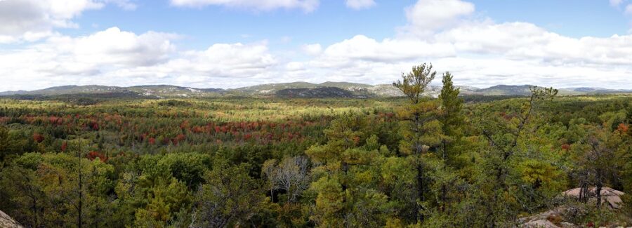
To the south, your eye moves along the shore from Collin’s Inlet and Philip Edward Island to the expanse of Georgian Bay. To the north, see the spectacular La Cloche Mountains.
Lake of The Woods Trail (3.5 km, 3 hours, moderate to difficult)
This loop trail encircles Lake of the Woods, traveling through a variety of forest types, from old growth stands to elevated rocky outcrops.
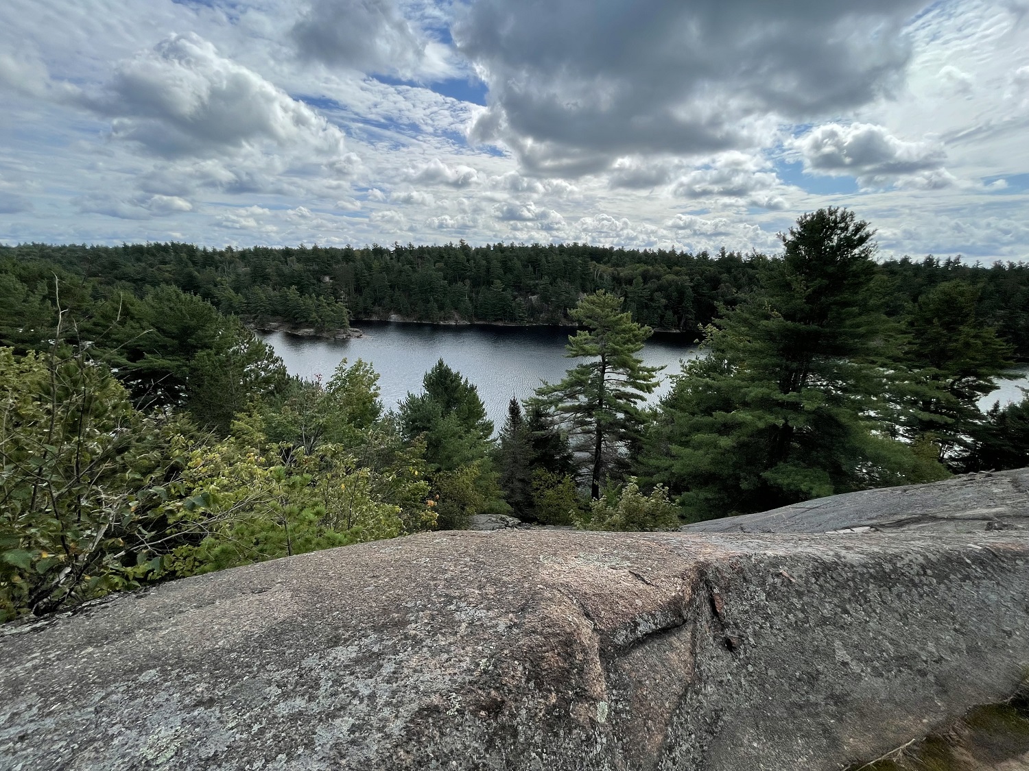
These outcrops offer excellent views of Silver Peak, 6 km to the west, and Lake of the Woods, below. At one point, the trail descends to the lakeshore where a short boardwalk connects to the lake’s only island.
14. Can I make a campfire along the way or at the top?
No. Fires can only be made in official firepits on designated campsites.
15. Can I camp on top of The Crack?
No. Camping is only permitted on official campsites, which must be reserved in advance.
If you’re planning a day hike, you’ll want to camp in Killarney’s George Lake Campground.
If you’re planning a backcountry trip, The Crack is part of the La Cloche Silhouette Trail, a strenuous, 80 km backcountry hiking loop (7-10 days). Backcountry campsites can be reserved by phone or online up to five months in advance of your arrival date.
16. Should I turn back if it rains?
You should strongly consider it.
Check the weather forecast before you start. If there are weather warnings for strong winds, or thunder and lightning, today is not the day for hiking.
Remember: this is a challenging trail even in the best conditions. Rain means a greater risk of injury. Those rocky scrambles and exposed roots are considerably more treacherous when wet. The Crack is also very exposed to lightning strikes.
Put your safety first and be honest about your experience and abilities. If you’re hiking with a group, make the decision whether to continue based on the abilities/safety the least-experienced member.
If you are a very experienced hiker, and decide to continue with your hike in rainy weather, be responsible. Choose proper footwear and raingear, and be sure you have a way to contact help if needed. Find more wet weather hiking tips here.
17. Should I be worried about bears?
When visiting our park, you are sharing the forest with animals, including birds, insects, and — yes — Black Bears.

Safe hiking practices significantly reduce any risk of an encounter. Respect bears’ space, and be a responsible park visitor.
18. What should I do if I get lost or hurt?
If you’re not sure what to do if you or a companion are lost or injured during a hike, that may be an indication that this trail is above your skill level. This is a good starting place to learn more about trail safety / navigation basics.
One of the easiest ways to get lost on this trail is to go too far, or to forget to turn around and come back at the top.
Keep following the red trail markers. If you go the wrong way after reaching the top, you’re heading out (best case) onto an 80 km backcountry trail or (worst case) into the unmarked wilderness. Follow the red markers back down the way you came.
In the event, you do get lost or injured:
- Call for help, if you are able. Dial 911 and share your location. Use your GPS coordinates or landmarks that you passed to help rescuers pinpoint your location. If your cell service is sketchy, try sending a text message – sometimes they go through when calls will not. This is where a satellite phone can be very important
- Keep calm. We know it’s easier said than done. Sit for a moment, conserve your energy, and try to collect your thoughts
- Stay put. It’s much easier for rescuers to find you if you stay in one place. Don’t keep wandering – find an open place and wait for help
19. Can I hike the trail in the winter?
Yes. Killarney is open 365 days of the year.
That said, if you think this is a tough trail in the summer, just imagine what it’s like under a blanket of snow and ice!
Only very experienced winter campers/hikers should tackle The Crack in the snowy season. It takes specialized gear and a very high skill level to do safely.
If you do plan a winter hike on The Crack, you must check in with the park before you start.
20. What can I do to protect the trail?
We’re so glad you asked!
With ever increasing use, The Crack has a lot of wear and tear. Erosion and overuse are a major challenge, and the trail has extensive root exposure in some areas (big thanks to the donors who recently helped us with some rehabilitation work!).
The best thing you can do to protect The Crack? Stay on the trail.
The route is carefully designed to avoid sensitive areas and direct hikers around areas with heavy damage and erosion. Don’t wander or take any “shortcuts.” Stay on the switchbacks — don’t hop them.
Aside from staying on the trail, remember to leave no trace. Pack all garbage out with you. This is an iconic piece of Ontario’s natural and cultural history; it deserves better than litter.