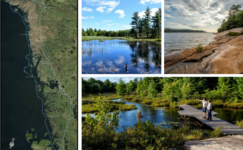
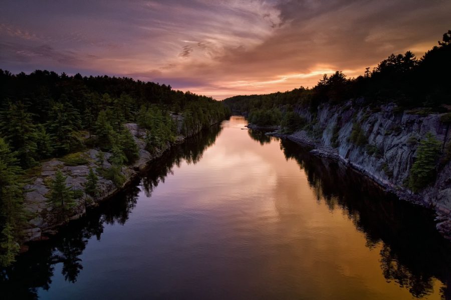
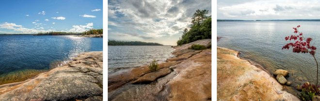
The eastern shore of Georgian Bay is a pink necklace of islands scattered on a turquoise sea. A freshwater sea, that is.
Georgian Bay is part of Lake Huron, and Huron is one of the Great Lakes, the largest expanse of freshwater in the world.
Eastern Georgian Bay is world class. In 2004, the area was designated as a world biosphere region by the United Nations Educational Scientific and Cultural Organization (UNESCO).
The formation of Georgian Bay
That necklace of islands makes up the largest freshwater archipelago in the world. There are so many islands along eastern Georgian Bay it’s known as the Thirty Thousand Islands.

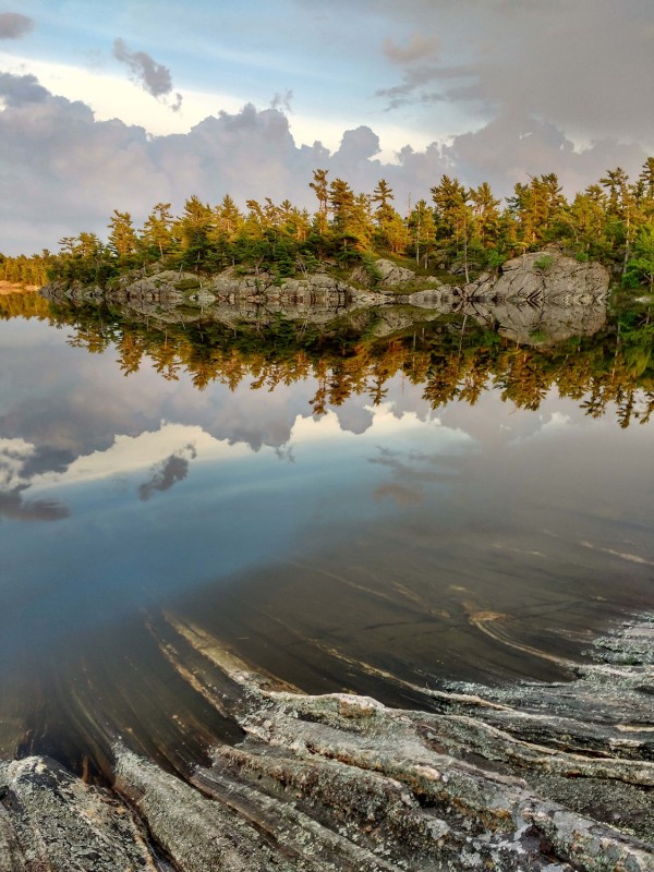
This incredible chain is the result of complex geology. The rocks are the folded roots of ancient mountains, with alternating softer and harder rock – the harder rock makes up the islands, and the softer rock has been eroded away to leave the channels and bays. Looking at a map, it is often hard to tell Georgian Bay from those inland waterways, and Georgian Bay waters can reach deep inland.
This permeable shoreline between the open waters of Georgian Bay and forested landscape of Central Ontario is a refuge for biodiversity. Biodiversity comes from the variety of living organisms and their interactions in a place. There are more than 100 different types of habitats along eastern Georgian Bay.
That complex coastline has made it more difficult to build roads, and communities along the Bay are small, so there tends to be more natural habitat. Many animals that are threatened elsewhere thrive here. More than 160 species of birds breed along eastern Georgian Bay. The region is also home to 44 species of mammals, and 34 species of reptiles and amphibians, including many species at risk. This incredible landscape became the basis for the creation of the Georgian Bay Biosphere Region.
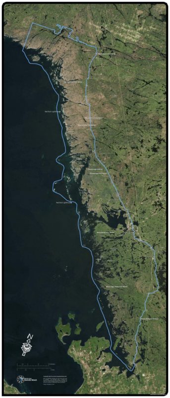
The Biosphere Region stretches for more than , from the Severn River at its southern end to the French River in the north. It takes in nearly 350,000 ha of forest, lakes, shoreline and islands.
Its designation was the result of years of hard work by a dedicated coalition of local residents, cottagers, First Nations representatives, government agencies and non-government organizations. Based in Parry Sound, Georgian Bay Biosphere Region Inc. (GBBR) was established in 1998 as a non-profit organization to develop the application for Biosphere Region status. There are 16 biosphere regions in Canada, and 600 around the world.
UNESCO requires that each designated biosphere region contain core areas that have legal protection. The GBBR contains one national park (Georgian Bay Islands), and more than half a dozen provincial parks. There are also several large conservation region with protection similar to parks. A number of First Nations communities with region lands lie within the Biosphere, and are now known to be refuges for many species at risk, as they are mostly undeveloped.
The Georgian Bay Biosphere Region promotes conservation and stewardship, as well as responsible and sustainable development. It isn’t a planning jurisdiction and doesn’t have legal authority to direct development. Its purpose is to foster and encourage stewardship in those who live there and visit it. It does this through public programs and workshops, education, research and monitoring programs. Part of the GBBR’s mandate is education.
Amazing places of GBBR
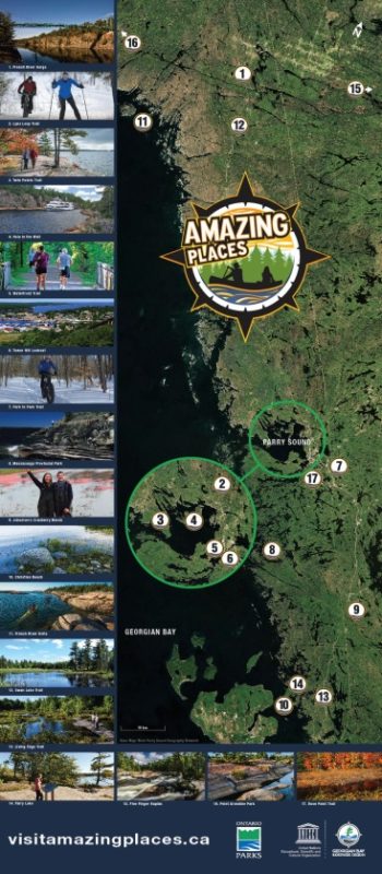 In order to get people outside and into the Biosphere, the GBBR staff adopted the Amazing Places program developed by the Fundy Biosphere Region in New Brunswick.
Amazing Places promotes locations in the Biosphere that are accessible to the public, and tell a story about the physical, biological and historical features of the Region. They are opportunities to explore, connect and be inspired.
Check out these seven Amazing Places:
French River Provincial Park
The 105 kilometre-long French River was designated the first Canadian Heritage River in Canada’s Heritage River System, recognizing it for its outstanding natural and cultural heritage and recreational opportunities. An important trade and travel route for Indigenous people from many nations for millennia, the river linked to a continent-wide trade network.
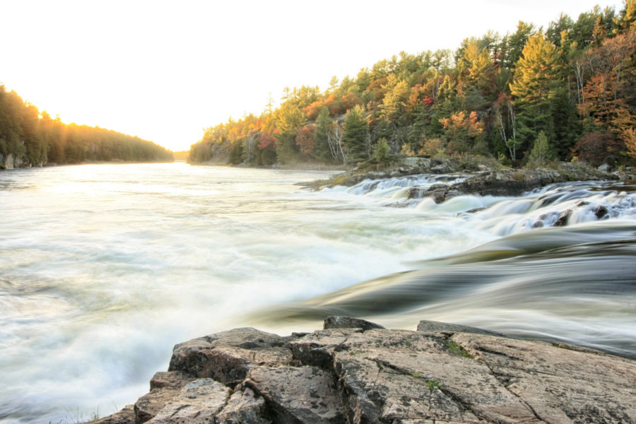
The French is a favourite of boaters and anglers, kayakers and canoeists for its classic Canadian Shield landscape and backcountry recreation.
Amazing Place: French River Gorge
Walk the easy path from the award-winning French River Visitor Centre to check out the gorge cliffs high above the French River for a spectacular view down an ancient fault in the earth’s crust.
For the more adventurous, the Recollet Falls Trail skirts the edge of the Gorge ending at Recollet Falls. Around the falls is a short portage that has been walked by a who’s-who of historic names, from Algonquin Chief Iroquet to Samuel de Champlain to Alexander Mackenzie.
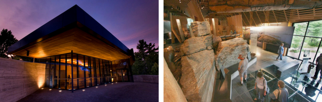
The French River Visitor Centre, located on Highway 69, is the trailhead for the Gorge and Recollet Falls Trail. Its exhibit hall “Voices of the River” tells stories of the people who have lived and travelled on the French.
Amazing Place: French River Delta
The Delta, where the French River enters Georgian Bay, is made up of many bedrock channels. Most river deltas are made of sediment that the river deposits itself. The French River follows many fault lines that were carved and sculpted by glacial ice and meltwater thousands of years ago.

The Delta is a large, roadless area, accessible only by water or a single road on its north eastern edge. It is home to many species at risk, which are often threatened by road mortality and habitat loss. The Delta is the northern limit of the range of the Eastern Massasauga Rattlesnake.
The outer edge of the Delta, where it meets Georgian Bay, is a myriad of islands and rocky islets, part of the Thirty Thousand Islands archipelago. This is the classic smooth pink rock and windswept pine landscape of eastern Georgian Bay.
Dokis First Nation
Dokis First Nation sits on Okikendawt, a large island in the middle of the French River, surrounded by this incredible landscape. For Dokis First Nation, this landscape is alive with spirits and stories. They have lived here for thousands of years, and their oral histories go back in time. Dokis provides access to the waters of the upper French River through a large marina. The Papase Trail ends at Five Finger Rapids.
Amazing Place: Five Finger Rapids
This Amazing Place is another of the French River’s many rapids and falls. It lies on the Little French River, which can be accessed by water or trail via the Dokis First Nation.

The Anishinabek name for the rapids is Zoongininjii, which means “Manitou’s strong hand.” Visitors can join a guided tour from Dokis First Nation to learn about the legends of the landscape, or arrange a water taxi to Five Finger Rapids.
Grundy Lake Provincial Park
Grundy Lake Provincial Park lies an hour south of Sudbury, this park contains a number of campgrounds nestled in amongst a landscape of lakes and pine-dominated forest.
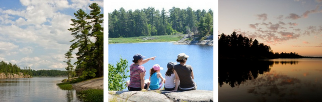
The park is perfect for families, with trails, canoeing and kayaking opportunities, sand beaches, and many nature programs through the summer and fall weekends.
Amazing Place: Swan Lake Trail
Grundy Lake represents the Biosphere’s inland lakes and forests. The park’s landscape was sculpted by the same forces of glacial ice and meltwater that formed neighbouring French River Provincial Park. Here, the ice and water formed the bedrock surface into undulating waves, with hills and hollows.
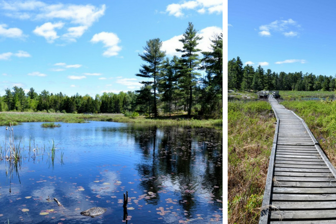
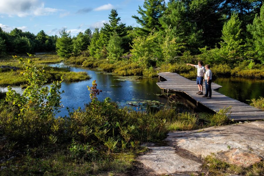
Swan Lake Trail crosses these hills, some of them dry and covered with lichen and Jack Pine. A boardwalk gives hikers a chance to see wetland plants up close, and maybe a resident Beaver, a Great Blue Heron, or even a rare Blandings Turtle.
Park naturalists monitor the turtles that live at Grundy Lake, especially the yellow-throated Blandings, one of a number of species at risk protected there. Guided hikes on the Swan Lake Trail are led by park naturalists through the summer months.
Killbear Provincial Park
Killbear occupies a peninsula that juts out into Georgian Bay and helps to enclose the bay of Parry Sound.

The Anishinabek word for the peninsula is Mko-neyaash or “Bear Point.” Bears can swim well, and the point is a shortcut around Parry Sound. The park and peninsula is like an island and a haven for Fox Snakes and Massasauga Rattlesnakes, both species at risk. Park naturalists have been monitoring the movements of both species for many years.
Amazing Place: Twin Points Trail
This trail is the perfect location to experience Killbear Provincial Park in just an hour or two. It passes through forest, over rock barrens, and along Killbear’s Georgian Bay shore, and leads to a hidden beach.
The rocky points in the trail’s name are wide expanses of smooth bedrock that were sanded down by the glacial ice over thousands of years. The trail begins in the park’s day use area, making it easily accessible for both day trippers and for campers at one of Killbear’s many campgrounds.
The Massasauga Provincial Park
The Massasauga Provincial Park protects a large expanse of the Thirty Thousand Island archipelago and Georgian Bay Coast between the Moon River and Parry Island and Parry Sound. It also contains a number of inland lakes and forest. But no roads. Or campgrounds.
It’s a great big roadless area, the largest on the southern coast of eastern Georgian Bay, and you can explore it if you have a paddle.
A prime canoeing area on the interior lakes, and kayaking and boating area out on the Bay, the park was named after the Massasauga Rattlesnake, a species-at-risk that has found refuge in this park and other protected areas along the coast. Roads are the snake’s biggest problem, so the park is perfect habitat for it.
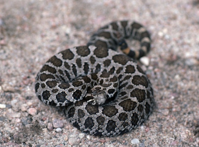
But don’t worry: bites are very rare, and it is a small snake with a limited amount of venom. Solid footwear will protect your feet from bites, and the snake’s buzzing rattle warns off intruders. Give it some space and it will retreat.
Amazing Place: Wreck Island Trail
While the whole of The Massasauga is an Amazing Place, Wreck Island sums up the park’s Georgian Bay side. Twisted patterns in the exposed bedrock shore contrast with the surrounding turquoise and blue waters, which makes for a striking landscape.

The island is thought to be the last resting place for the side-wheel paddle steamer Wabuno, which sank in a November storm in 1879. Various bits and pieces of shipwreck may be the ship, including a hull near Wreck Island. Crew and passengers were never seen again. The island is a reminder of the treacherous waters of the Great Lakes.
Six Mile Lake Provincial Park
Six Mile Lake sits near the southern edge of both Muskoka and the Canadian Shield. The park contains that classic Shield landscape of pink granite, blue water and towering pines. Just two hours north of Toronto, Six Mile Lake provides a piece of Northern Ontario that’s nearby.
The park’s Shield landscape is home to many species at risk, including the Five-lined Skink, Ontario’s only native lizard. Six Mile is “Skink Central” with lots of habitat available – rocky cracks and crevices they can escape to and hunt for insects.
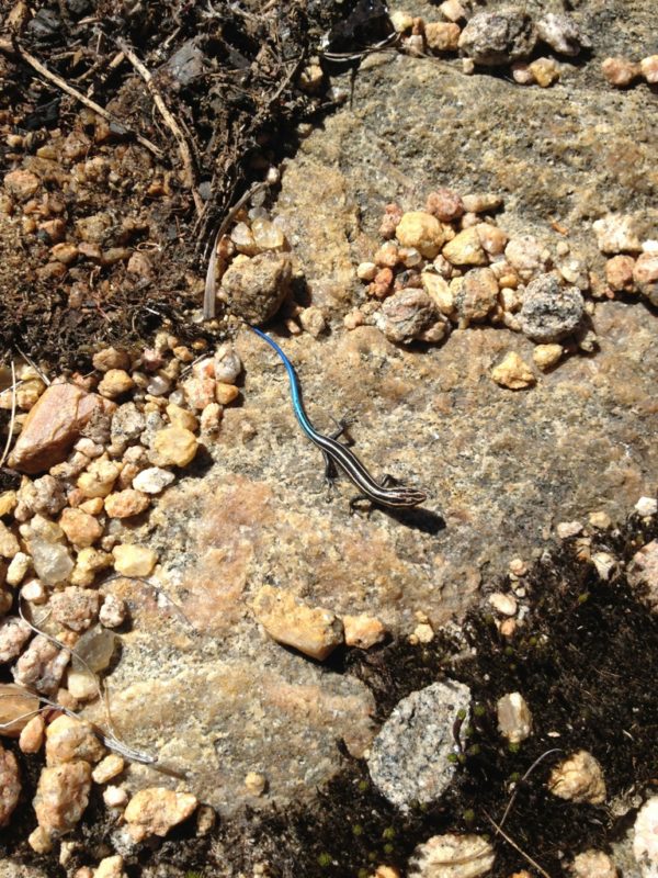
If we’re going to have only one lizard, one with an electric-blue tail is a good choice!
Amazing Place: The Living Edge Trail
This trail wanders past granite rock barrens, through mixed forests and around beaver ponds and meadows for a kilometre. The Living Edge Trail provides a perfect glimpse of what makes little Six Mile Lake Provincial Park big on the inside.
Keep your eyes peeled, and you may see the beaver cruising its pond, or a Fox Snake sunning on a rock, or the electric-blue tail of a skink!